Reservation Lines Blurred: Navigating Indian Country After McGirt
Reservation Lines Blurred: Navigating Indian Country After McGirt


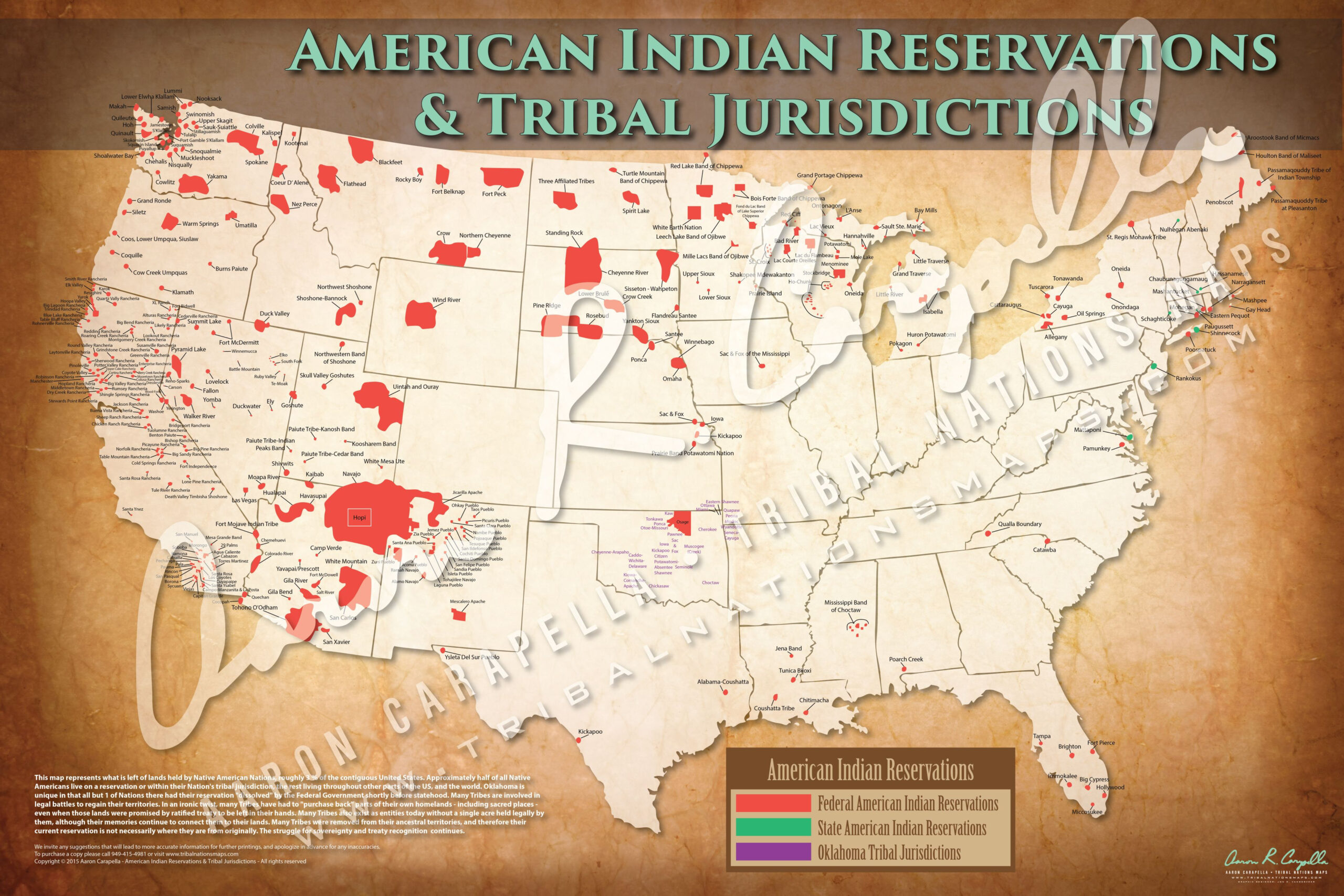
The legal landscape of Indian Country has been shaken up, and it’s not just the dust settling. The landmark Supreme Court decision in McGirt v. Oklahoma has sent ripples across the nation, impacting everything from criminal jurisdiction to land ownership. The decision, which affirmed the Muscogee (Creek) Nation’s reservation status in eastern Oklahoma, has thrown a spotlight on the complex and often misunderstood issue of Indian reservations. And guess what? It’s got people scrambling for Indian reservation maps, trying to make sense of the new reality.
Before McGirt, many folks, even those living in the heart of Indian Country, were oblivious to the boundaries of reservations. Sure, they knew about the casinos and maybe the tribal government offices, but the exact lines on the map? Not so much. Now, thanks to McGirt, everyone’s a little more curious.
Related Articles: Reservation Lines Blurred: Navigating Indian Country After McGirt
- Unveiling the Largest Native Tribes in California: Discoveries and Insights
- Discover the Enchanting Flavors of Indian Restaurant Bellagio Jakarta
- Unveiling the Enchanting Flathead Indian Reservation: A Journey of Discovery
- Unveiling the Enigma: Indian Reservations in America – Discoveries Await
- Uncover the Enigmatic World of Michigan's Indian Reservation
But here’s the thing: McGirt wasn’t a one-off. It’s opened the door for other tribes to assert their sovereignty, and that means the map is going to keep changing.
So, what does all this mean for you? If you live in a state with historical tribal lands, you’re going to want to take a closer look at the map. You might be surprised to find yourself living within a reservation, or at least near one. And that could have a big impact on your life, whether it’s the laws you’re subject to, the services you can access, or even the land you own.
Enter the world of Indian reservation maps. These aren’t just static pieces of paper anymore. They’re dynamic, evolving, and constantly under construction. And they’re becoming increasingly crucial for understanding the legal and cultural realities of Indian Country.
But navigating this new world can be tricky. Where do you even start? What are the most accurate maps available? And what do all those lines and markings really mean?
Let’s break it down.
The McGirt Effect: More Than Just Lines on a Map
The McGirt decision has far-reaching implications beyond just redefining geographic boundaries. It’s a major victory for tribal sovereignty, affirming the inherent right of tribes to govern themselves and their lands. This means more than just drawing lines on a map; it’s about recognizing the unique legal and cultural status of tribal nations within the United States.
Here’s what McGirt means in practical terms:


- Criminal Jurisdiction: The decision has shifted criminal jurisdiction in parts of Oklahoma, with tribal courts now having authority over certain crimes committed by both Native Americans and non-Natives within reservation boundaries.
- Land Ownership: The decision has raised questions about land ownership and the rights of tribes to regulate resources on their lands, including water and energy development.
- Tribal Services: The decision has increased access to tribal services, like healthcare and education, for eligible individuals within reservation boundaries.


But McGirt also brings challenges:
- Uncertainty: The legal ramifications of McGirt are still being debated and interpreted, leading to confusion and uncertainty for individuals and businesses operating within affected areas.
- Resource Allocation: The increased demand for tribal services can strain resources and create challenges for tribal governments in meeting the needs of their communities.
- Intergovernmental Relations: The decision has sparked tensions between state and tribal governments over jurisdiction and resource management, leading to complex negotiations and potential conflicts.

Navigating the New Reality: The Role of Indian Reservation Maps
In this evolving landscape, Indian reservation maps have become essential tools for understanding the legal and cultural realities of Indian Country. They provide a visual representation of tribal boundaries, helping individuals and organizations navigate the complexities of jurisdiction, resource management, and tribal sovereignty.
Here’s what you need to know about Indian reservation maps:
- Not All Maps Are Created Equal: The accuracy and reliability of Indian reservation maps vary widely. It’s crucial to choose maps from reputable sources, like the Bureau of Indian Affairs (BIA) or tribal websites.
- Dynamic and Evolving: Indian reservation maps are not static; they are constantly being updated and revised as tribes assert their sovereignty and legal boundaries are redefined. It’s important to stay informed about the latest changes and consult the most current maps available.
- Beyond Geographic Boundaries: Indian reservation maps are more than just lines on a page. They reflect the complex history, culture, and legal status of tribal nations, and they serve as a reminder of the ongoing struggle for self-determination and sovereignty.
Where can you find accurate Indian reservation maps?
- Bureau of Indian Affairs (BIA): The BIA website provides maps of recognized Indian reservations and trust lands, which can be accessed through their "Land and Resources" section.
- Tribal Websites: Many tribal websites offer maps of their reservation boundaries, along with information about their government, services, and cultural resources.
- Third-Party Resources: Several third-party websites and organizations provide maps of Indian reservations, but it’s important to verify their accuracy and source.
- GIS Data: Geographic information systems (GIS) data is increasingly being used to create interactive and detailed maps of Indian reservations, allowing for more accurate and comprehensive analysis.
Understanding the Language of the Map: Decoding the Symbols and Markings
Indian reservation maps use a variety of symbols and markings to represent different aspects of tribal lands and sovereignty. Here’s a breakdown of some common elements:
- Reservation Boundaries: The outer lines of the map typically represent the official boundaries of the reservation, as recognized by the federal government.
- Trust Lands: Areas within the reservation that are held in trust by the federal government for the benefit of the tribe are often designated with a specific symbol, such as a shaded area or a dotted line.
- Tribal Jurisdiction: The map may indicate areas where the tribe has exclusive or concurrent jurisdiction, such as criminal law enforcement or environmental regulations.
- State Jurisdiction: Areas where the state retains jurisdiction are often marked with a different symbol or color.
- Other Tribal Lands: The map may also include other tribal lands, such as allotments or off-reservation trust lands, which are not part of the main reservation but are still under tribal jurisdiction.
It’s important to note that the markings and symbols used on Indian reservation maps can vary depending on the source and purpose of the map. Always refer to the map’s legend or accompanying documentation for a clear understanding of the symbols and their meaning.
Navigating the Legal Landscape: Understanding the Implications for Individuals and Businesses
The changing legal landscape of Indian Country, as shaped by McGirt and other recent decisions, has significant implications for individuals and businesses operating within or near reservation boundaries. Here are some key considerations:
- Criminal Law: If you’re living or working within a reservation, you need to be aware of the tribe’s criminal laws and the potential for dual jurisdiction. This means that you could be subject to both state and tribal laws, and you may need to comply with both.
- Land Use and Development: The tribe may have regulations governing land use and development within the reservation, including zoning, environmental protection, and resource extraction. It’s crucial to consult with the tribe before undertaking any development projects or activities.
- Tribal Taxes: Tribes have the authority to impose taxes on businesses and individuals operating within their reservations. You need to be aware of the tribe’s tax laws and comply with them accordingly.
- Employment and Labor: Tribal governments may have their own employment and labor laws, which can differ from state laws. Businesses operating within reservations need to ensure compliance with tribal employment regulations.
- Environmental Protection: Tribes have a responsibility to protect the environment within their reservations, and they may have stricter environmental regulations than the state. It’s essential to comply with tribal environmental laws and regulations.
It’s crucial to seek legal advice from qualified professionals to understand the specific legal implications of operating within or near a reservation. Tribal attorneys and legal experts can provide guidance on navigating the complex legal landscape and ensuring compliance with both state and tribal laws.
Beyond the Legal Landscape: The Cultural Importance of Indian Reservation Maps
Indian reservation maps are not just legal tools; they are also powerful symbols of cultural identity and self-determination. They represent the enduring presence of tribal nations in their ancestral homelands, and they serve as a reminder of the ongoing struggle for recognition, sovereignty, and cultural preservation.
Here are some ways in which Indian reservation maps hold cultural significance:
- Historical Continuity: The maps highlight the historical continuity of tribal nations, demonstrating their enduring connection to their lands and their resilience in the face of colonization and assimilation.
- Cultural Identity: The maps serve as a visual representation of tribal identity, showcasing the unique cultures and traditions that have been passed down through generations.
- Self-Determination: The maps are a powerful symbol of tribal self-determination, demonstrating the right of tribes to govern themselves and their lands.
- Cultural Resources: The maps can be used to identify and protect cultural resources, such as sacred sites, burial grounds, and traditional gathering places.
By understanding the cultural significance of Indian reservation maps, we can gain a deeper appreciation for the resilience and diversity of tribal nations and their enduring connection to their ancestral homelands.
Looking Ahead: The Future of Indian Reservation Maps
The legal and cultural landscape of Indian Country is constantly evolving, and Indian reservation maps will continue to play a crucial role in navigating this complex and dynamic environment. As tribes continue to assert their sovereignty and redefine their boundaries, the maps will need to be updated and refined to reflect these changes.
Here are some key trends shaping the future of Indian reservation maps:
- Increased Use of GIS Data: Geographic information systems (GIS) data is increasingly being used to create interactive and detailed maps of Indian reservations, allowing for more accurate and comprehensive analysis.
- Integration with Tribal Websites: Tribal websites are increasingly incorporating maps of their reservations, providing access to information about their government, services, and cultural resources.
- Collaboration with State and Federal Agencies: There is a growing need for collaboration between tribal governments, state agencies, and federal agencies to ensure the accuracy and accessibility of Indian reservation maps.
- Public Awareness: There is a growing need for public awareness about the legal and cultural significance of Indian reservation maps, helping to foster understanding and respect for tribal sovereignty.
As we navigate this new era of tribal sovereignty, Indian reservation maps will continue to be essential tools for understanding the legal, cultural, and historical realities of Indian Country. By embracing these maps as symbols of resilience, self-determination, and cultural identity, we can contribute to a more just and equitable future for all.
FAQ: Indian Reservation Maps Post-McGirt
Q: What are the most accurate Indian reservation maps available?
A: The most accurate maps are typically those provided by the Bureau of Indian Affairs (BIA) or tribal websites. However, it’s important to note that maps are constantly being updated, so it’s always best to consult the most current information available.
Q: How often are Indian reservation maps updated?
A: There is no set schedule for updating Indian reservation maps. They are typically updated as needed, based on changes in tribal boundaries, legal decisions, or other significant events.
Q: How can I find out if I live within a reservation boundary?
A: You can use online mapping tools, such as Google Maps or ArcGIS, to search for Indian reservation boundaries. You can also contact the BIA or the relevant tribal government for information about reservation boundaries.
Q: What are the implications of living within a reservation boundary?
A: Living within a reservation boundary can have significant implications for your legal rights, access to services, and the laws you are subject to. It’s important to consult with legal professionals and tribal officials to understand the specific implications for your situation.
Q: What can I do to support tribal sovereignty and self-determination?
A: You can support tribal sovereignty and self-determination by educating yourself about the history and culture of tribal nations, supporting tribal businesses and organizations, and advocating for policies that promote tribal self-governance.
Remember, the lines on the map are more than just lines. They represent the history, culture, and sovereignty of tribal nations, and they are a reminder of the ongoing struggle for recognition and self-determination. By understanding the importance of Indian reservation maps, we can all contribute to a more just and equitable future for all.


Closure
Thus, we hope this article has provided valuable insights into Reservation Lines Blurred: Navigating Indian Country After McGirt. We appreciate your attention to our article. See you in our next article!


